
Old Bloke On An Old Bike
The story of the restoration of a 1950s classic bicycle for a Land's End – John O'Groats charity ride in aid of Alzheimer's Society
30 May 2015: Training begins….

photo courtesy Sean Hickin
A chance to do a long ride yesterday, to begin the year-long training campaign. We arranged to meet some of the family for lunch at 12.15 at Hemingford Grey – a lovely village on the river Great Ouse between Cambridge and Huntingdon. I decided to be ambitious and take the Ellis-Briggs for her longest outing yet, riding the whole distance.

I used the CycleStreets site to plan the route – a very useful resource, that gives a choice of three suggested routes between any two locations: quietest, fastest and balanced. I chose the balanced route, which would have worked out at about 70 miles if I had managed to stick to it.
I downloaded the route into a Garmin cycle GPS unit which works something like a car satnav. As backup, I also had three maps from Sustrans covering the relevant bits of the National Cycle Network. It should have gone well…
I started at 5a.m. (a great time to be out on the bike – the roads are almost deserted, just like cycling was in the 1950s, I suppose), and I immediately got lost in my own home town, Colchester, trying to pick up a shortcut to the start of the route. That wasted half an hour going round in circles.
Everything then went fine until close to Newmarket, when I took a wrong turn and then made the catastrophic mistake of allowing the GPS to “recalculate” the route to get me back on course – more going round in circles. Unfortunately the Sustrans maps aren’t detailed enough to be very helpful when you’ve missed the route in a maze of country roads. I was clearly going to be a bit late.
Then came Cambridge. Well, I used to live in Cambridge, but the place has really changed, it’s now pretty chaotic. There is a nice convenient NCN route through the northern part of Cambridge that started off well, but… The NCN route markers are only small sticky plastic signs stuck onto bits of street furniture. They’re easy to miss and some seem to have been removed by wellwishers. I followed the Cambridge route (followed in turn by someone who’d already got lost and was relying on me), but it petered out, dumping us at a busy major road junction. The GPS then very helpfully tried to guide me onto the A14 – a death sentence.
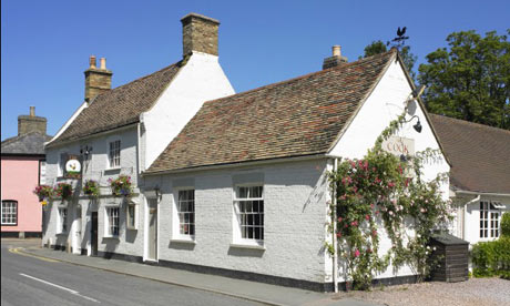
Anyway, I eventually arrived at the (really nice) gastro-pub, The Cock, at 1.45, starving hungry. I’ve never enjoyed a meal more, but I wasn’t very popular with the others, who’d finished eating ages before and were waiting patiently.
Altogether, the computer says that I covered 83 miles – but there was a problem with the GPS and it missed a section of the route – about 5-10 miles, I’d guess. So it’s possible that I did 90 miles. Average speed was 12 mph with a maximum of 31 mph. Not too bad, given the blustery headwind and the messing about looking for the route. But the average speed for the last 15 miles was only 10.5 mph. I think that was due to nutrition – I only took with me water, a banana and a cereal bar , and that wasn’t enough. I definitely felt low in energy at the end. I’m fine today – just a slightly stiff neck, a mild ache in my right knee, slightly sore achilles tendons and – mysteriously – a really sore tip of my left big toe. How did that happen?
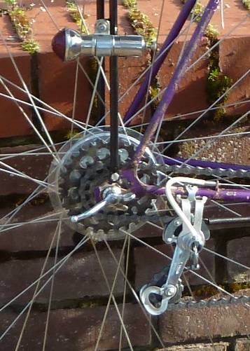
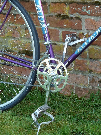
The bike did beautifully. She was a delight to ride. The only significant problems were the toeclips and straps, which I haven’t really got used to yet, and down-shifting on the rear gear, which works fine but usually with a horrible noise. Amazingly, the “suicide” front gear works like a dream and I’m quite used to it now.
About me
I'm Steve Pudney, a health economist now at the University of Sheffield. I carry out research on policy on disability, and I'm very concerned about the prospects for many disabled older people. I'm a keen cyclist and so decided to do something practical to help by raising money for Alzheimer's Society. Please consider supporting us.
